Transport and travel
Our sustainable transport hierarchy is set out in our City Mobility Plan and clearly prioritises walking and wheeling, then cycling, then public transport.
In line with this, the proposed design for George Street improves the quality, range and integration of sustainable travel options.
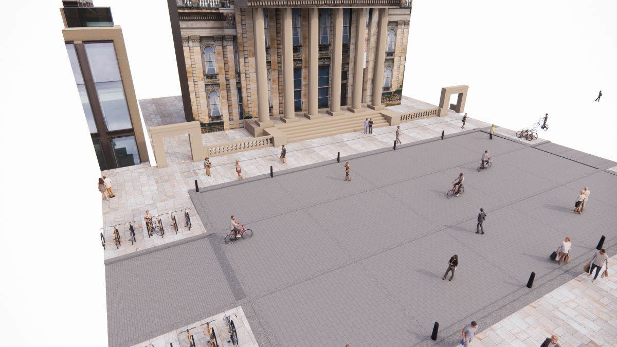
Generous space for cyclists allows for family and leisure cycling as well as commuting. This is safe and clearly marked with extensive cycle parking along the length of the street.
Key transport considerations
- The City Centre Transformation strategy aims to develop transport networks and enhance public spaces which enable safe movement in a sustainable way addressing the climate emergency and providing a walkable city centre.
- Through the delivery of this strategy and the wider City Mobility Plan, the city centre will become largely car-free by 2030.
- As part of this ambitious change vehicle access to George Street will be significantly restricted to essential access only, which includes blue badge parking.
The Meadows to George Street and City Centre West to East Link active travel routes will provide direct cycling links to George Street and other parts of the city.
Walking and wheeling
The design focuses on creating a better place for walking and wheeling and the value of George and the First New Town as a city centre destination. To achieve this, all non-essential parking will be removed and space redefined to include wider pavements and landscaped seating areas within each block.
The pedestrian areas will be delineated by a low upstand kerb providing designated clutter free, accessible areas for walking and wheeling, using an appropriate range of high-quality finishes.
The largely car-free design will support walking and wheeling through and across the First New Town and will include
- improved pedestrian crossing facilities at each junction along George Street. This will include reduced crossing distances, single stage crossings and adjusted traffic signal phases to increase pedestrian crossing time
- informal pedestrian crossings at multiple points throughout each block
- significantly wider, clutter free pavements on George Street with landscaped seating areas.
Cycling
Vehicle traffic flow along George Street will be restricted to very low levels with the existing central space designed to prioritise cycling, similar to a European-style cycling street.
Cycle Street
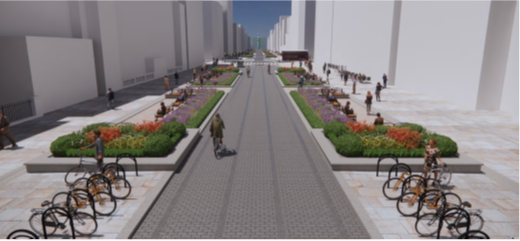 Flat topped whinstone setts are proposed on the cycle street/ carriageway of George Street, allowing a level surface for cyclists, whilst being appropriate to UNESCO World Heritage Site.
Visually the carriageway is set as 5.8 metres with materials but has additional overrun space of 0.8 metres to allow for large vehicles turning when they have access.
The design will include the following key elements
- largely car-free, cars limited with access barriers, one-way system and restricted turns
- contra-flow arrangement to allow cyclists to travel in both directions along the street
- cycling is prioritised in George Street and directly connects with the Meadows to George Street and City Centre West to East Link cycle route schemes at Hanover Street South, St Andrew Square and Charlotte Square
- improved pedestrian crossings at junctions
- increased cycle parking provision
- signalised junction phases arranged to improve cycle connectivity along the main City Centre West to East Link and Meadows to George Street cycle routes.
Loading and parking
Adequate loading space is provided for deliveries for businesses in the First New Town. Parking is removed from George Street except for blue badge holders.
The key proposals include:
- loading throughout George Street and the wider First New Town, based on needs identified by a street survey.
- daily deliveries and servicing, will be managed with a daily access window - 7pm to 10.30am Monday to Saturday and 7pm to 12.30 noon Sunday. Outside these access windows this flexible space can be used for other street activities, such as events or café/bar spill out space as appropriate.
- loading on George Street will be consolidated to dedicated loading bays and central spaces, equally distributed along the north and south sides of the street.
- shared-use residents and short-stay Pay and Display parking will be retained within the cross streets.
Buses and other traffic
A review of the public transport network was considered as part of the City Mobility Plan and proposes that bus access within George Street will be removed.
Access to local and national bus networks will still be available from the adjacent side cross streets including Hanover Street. Tram stops are also located in St Andrew Square and Princes Street.
The key proposals include restricted access
- for buses (including tour buses) on George Street although Frederick and Hanover Streets will remain as core public transport corridors
- for taxi and private hire car users between 7pm and 6am Monday to Sunday to support night time safety and the local economy. This will be 24 hours 7 days a week for passengers with Blue Badge or TaxiCard.
- for general traffic on George Street although maintained within the cross streets.
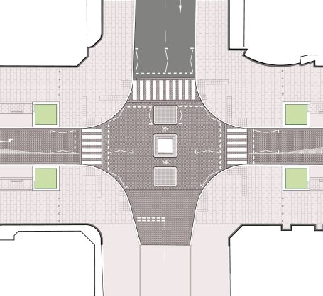
Junctions
We have designed the junctions to prioritise walking, wheeling and cycling, and then public transport. They respect the original masterplan with its symmetrical and consistent layout.
We have also considered the different traffic needs on the intersecting streets such as bus access on Frederick Street, Hanover Street and South and North St David Street.
Drivers will only be able to turn left at Castle Street, Frederick Street and Hanover Street junctions. This allows traffic numbers to stay low for cyclist safety and to discourage drivers using George Street as a through route.
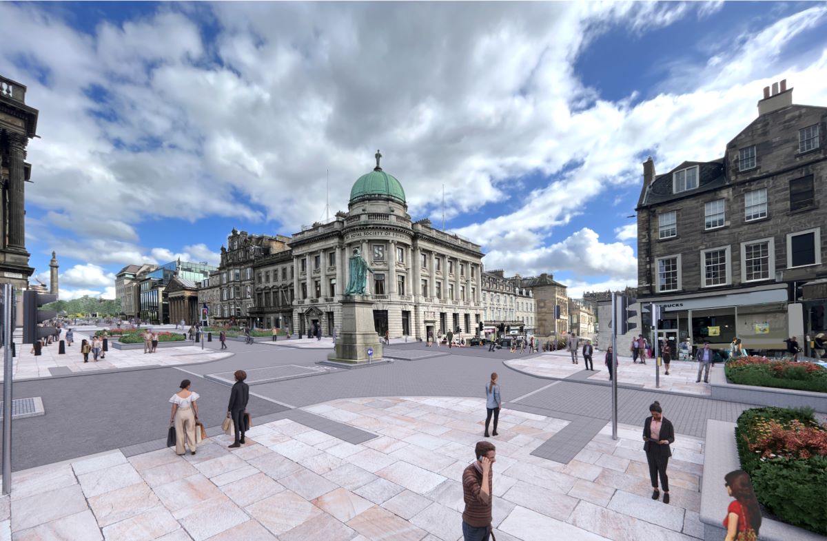
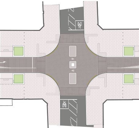
Diagram: proposed layout for the HanoverStreet/George Street junction, showing zebra crossings on all four sides of the statue.
Charlotte Square
The Charlotte Square project, links George Street to the City Centre West to East Link from Randolph Place.
- prioritises movement along the cycle street
- zebra crossings rather than signalised crossings
- left hand turn only for vehicles travelling from George Street to North Castle Street
- no right turns for motor traffic.
Castle Street
- prioritises movement along the cycle street
- zebra crossings rather than signalised crossings
- left hand turn only for vehicles travelling from George Street to North Castle Street
- no right turns for motor traffic.
Frederick Street
- signalised crossings
- left hand turn only for vehicles travelling from George Street to Frederick Street North.
- no right turns for motor traffic.
Hanover Street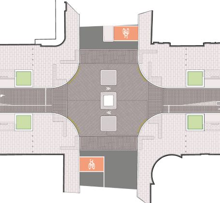
- remains a vital route for buses
- connects the George Street cycle street with the Meadows to George Street cycle route
- signal controlled pedestrian crossings
- cycles turning right from Hanover Street are able to use the gap space around the monument as a safe waiting space or perform a two-stage right turn
- no right turns for motor traffic.
St Andrew Square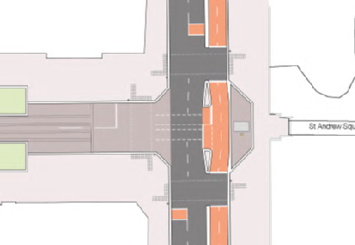
- North and South St David Streets remain an important bus route
- North St David Street includes a cycle route as part of the City Centre West to East Link
- move the James Clerk-Maxwell statue to the west entrance to St Andrew Square. This will simplify the layout of the junction. This has been discussed with the sculptor, Alexander Stoddart, and the owners of the statue, the Royal Society of Edinburgh. It will also be subject to planning consent.
Central spaces
Large, clutter free areas in the mid sections of each block are located outside prominent buildings in the middle of each block, such as the Dome, the Assembly Rooms and St Andrew’s and St George’s West church.
They will help
- slow down permitted traffic
- provide informal street crossing points mid-block
- provide spaces where appropriately scaled, temporary events can be hosted on the street.
Ramped kerbs into the central spaces will help to emphasise the priority for anyone walking or wheeling to vehicles and cyclists.